Visualize spatial data directly from SQL Server in Tableau 2018.1


We recently announced our 2018.1 release, with incredible capabilities, including the ability to connect to spatial data directly from Microsoft SQL Server.
Now you’re just a double-click away from visualizing spatial data stored as “geography-type” in SQL Server. Alongside support for native spatial data, Tableau 2018.1 also includes new RAWSQL functions that can leverage the spatial operations from the database and allow you to create calculations that return generated spatial objects.
Get started with spatial data
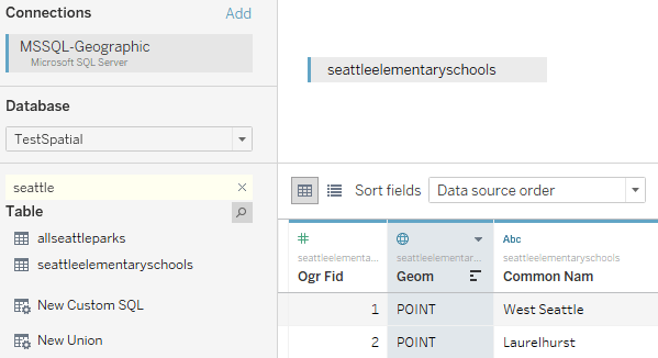
Tableau will recognize if your table has a spatial field and allow you to utilize it, with no intermediary steps. Just drag and drop the geographic field to get started.

Using spatial operations
Connections to SQL Server support Custom SQL queries. You can use a Custom SQL query to leverage operations supported by the database. Let’s say you wanted to understand how many parks are located near schools. You could perform a proximity analysis using the query below to produce the following visualization. This query uses a spatial join based on a buffer of the schools’ point geometry.
SELECT
S.[common nam] as SchoolName,
P.[common nam] as ParkName,
S.geom.STBuffer(750) as circle_geom,
P.[Geom] as park_geom
FROM
TestSpatial.dbo.seattleelementaryschools S
LEFT JOIN
TestSpatial.dbo.allseattleparks P
ON
S.geom.STBuffer(750).STIntersects(P.geom) = 1

Make the data dynamic by adding parameters to the query. You can also apply a buffer to the park geometries to make them more prominent and to create a polygon geometry that can be used in further analysis.
SELECT
S.[common nam] as SchoolName,
P.[common nam] as ParkName,
S.geom.STBuffer(
P.[Geom] as park_geom
FROM
TestSpatial.dbo.seattleelementaryschools S
LEFT JOIN
TestSpatial.dbo.allseattleparks P
ON
S.geom.STBuffer(

Expand your analysis with RAWSQL
Support for SQL Server Spatial includes a new set of RAWSQL functions that are usable in calculations. RAWSQL functions allow you to pass values into a SQL statement where the query is executed when the calculated field is utilized within the worksheet. This means you can leverage the spatial operations supported by the database to generate a new spatial object. The calculation below returns the INTERSECTION of two spatial objects—in this case, the school and park buffers. STIntersection is like a cookie-cutter operation. The resulting geometry will represent only the area that was shared by the two inputs.
RAWSQL_SPATIAL("Select %1.STIntersection(%2.STBuffer(200))",[circle_geom], [park_geom])
You can put buffered parks and the intersection results on a dual axis to produce a visualization that only shows the areas that overlap between the two fields.

We’re so excited to expand Tableau’s geospatial capabilities, allowing you to answer more location-based questions than ever before. For customers using SQL Server, this eliminates the need to pre-process data into Shapefiles for use in Tableau. Instead, you can maintain a live connection with your database to leverage all of its capabilities.
Join the pre-release community to test new geospatial features as they’re released in beta. We’re excited to see how you leverage this feature to create even more beautiful (and useful) maps!
For more information on this feature, read up on SQL Server documentation for geography types or visit the Tableau Help page. Learn about other features in the 2018.1 release on our feature highlights page.
相关故事

How Team USA uses data to build a digital HQ
 2022/02/08
Data trends that will impact you in 2022

Healthcare Analytics Hub Starter Kit: Get the data you need faster
 2019/10/18
The purpose of the Healthcare Analytics Hub Starter Kit is to provide a sample of what your healthcare app could look like. It’s not a complete solution; instead, it’s focused on what’s possible. Please contact your Tableau Account Manager to get started today!
Subscribe to our blog
在您的收件箱中获取最新的 Tableau 更新。