Tableau 10 includes more maps data, multilingual auto detection


Update: Tableau 10 is here! Download now to try out the feature outlined below.
Building maps just got even easier in Tableau 10! We’ve added more postal codes, more administrative boundaries, and more cities. We’ve also enhanced our geographic-role detection logic that will help you go from data source to viz even faster!
More postal codes
You may remember we added postal codes for almost all of Europe in Tableau 9.3. Now, with Tableau 10, we’ve expanded our global coverage for postal data to include countries in Asia as well as Central and South America. The list of supported countries now includes: India, Singapore, Brazil, Mexico, Argentina, Costa Rica, and Taiwan. We’ve also updated the postal codes for Australia.
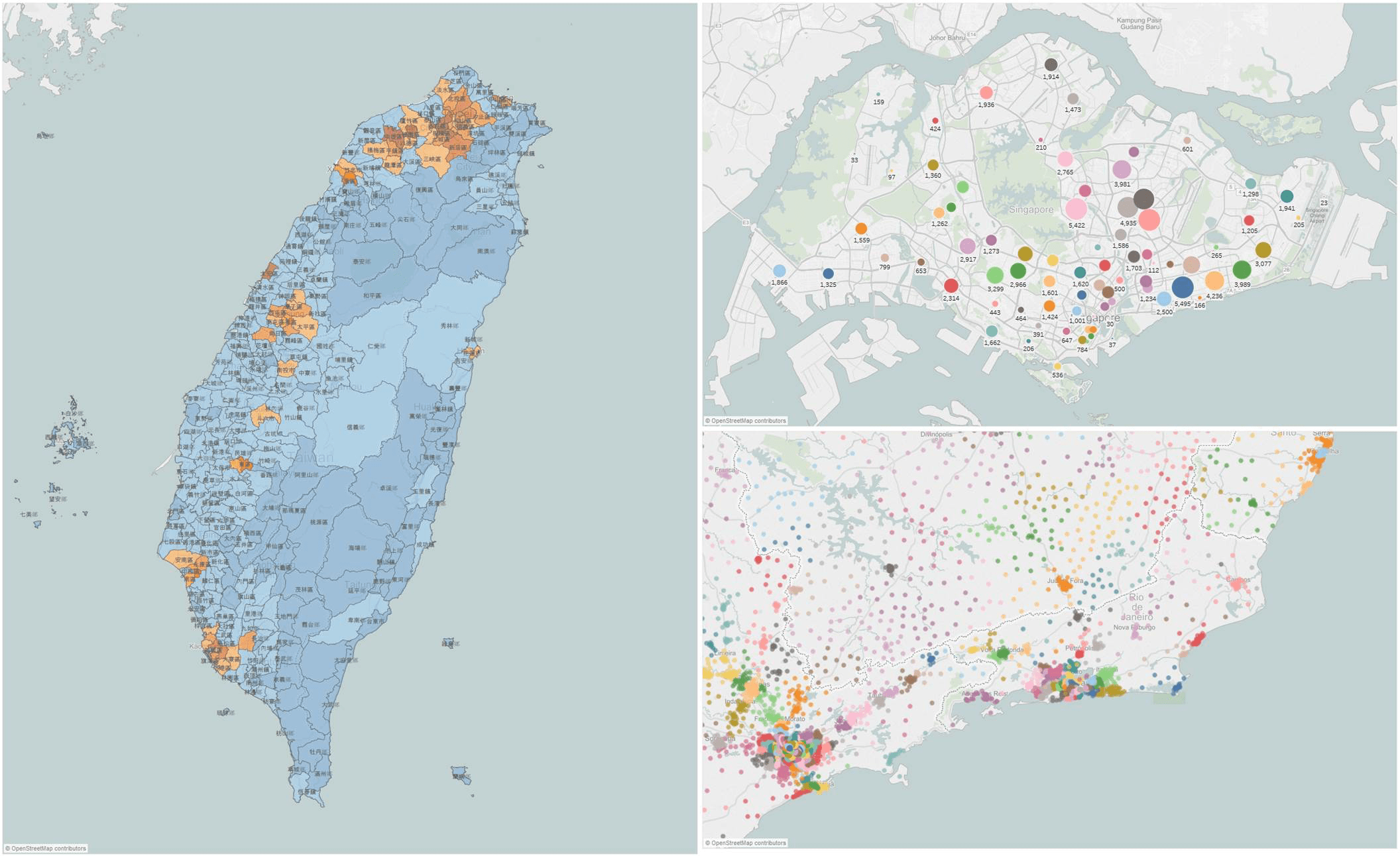
Population of Taiwanese cities, districts, and, counties (left); Singapore postal codes aggregated to two digits using custom territories (upper right); Brazilian postal codes by postal code sector (lower right).
More administrative and city-level data
In Tableau 10, we've added new administrative divisions for several countries. Under the “county” geographic role, you can now geocode districts of Hong Kong, South Korean sigungu (metropolitan areas), and third-level administrative divisions of Taiwan made up of townships, districts and county-level cities. You can also geocode France's overseas territories.
In addition, we've updated county-level data in Ireland and Kenya, and added additional cities throughout Western Europe.
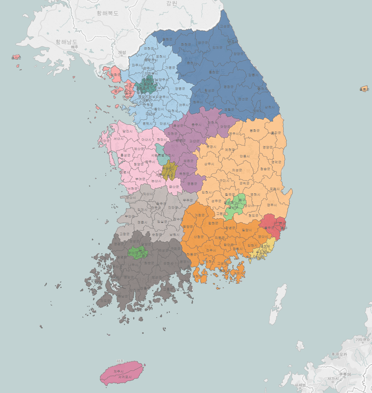
South Korean metropolitan areas consisting of –si, -gun, and –gu are now geocodable in Tableau 10.
Automatic detection of geographic data
If your data has column names that are commonly used for geographic data, Tableau 10 will automatically assign them the appropriate role. Tableau has always done this for English (for example, if you have a field called “City,” it will be assigned the geographic role of “city” when connecting to the data), but we’ve expanded this feature to also cover common terms in German, French, Portuguese and Spanish. That means ciudad, cidade, ville, and stadt will all be automatically detected as city geographic roles in Tableau 10.
Join the beta
These are just a few of the dozens and dozens of new features in Tableau 10. You can also build your own custom territories, then use those as your base analysis.
We have a timeline for getting Tableau 10 out the door, but we’d first like to get solid usage in beta and fix any bugs. We want your feedback as early as possible to catch any issues and ensure the new features are great.
If you haven’t yet, check out our beta program to learn more and sign up. The beta program is available for existing Tableau customers. Customers with an active maintenance license can upgrade for free when Tableau 10 is released.
Learn more about Tableau 10
Tableau 10 includes a brand new look and feel, and a host of new features to help you prep, analyze, and share your insights even faster. Check out our Coming Soon page for details.
- Uncover patterns in your data with Tableau 10’s clustering feature
- Quickly find marks in context with Tableau 10's new highlighter
- Build your own custom territories in Tableau 10
- Do more with bar charts in Tableau 10
- Integrate your data with cross-database joins in Tableau 10
- As requested, you can filter across data sources in Tableau 10
- Do more with APIs in Tableau 10
- Tableau 10 includes even more data-source options
- Connect directly to Google Sheets in Tableau 10
- (Finally!) see and understand your IoT data with our Google Sheets connector
- Connect directly to your QuickBooks online data in Tableau 10
- Favorite your data sources in Tableau 10
- Check out the beautiful look and feel of Tableau 10
- Format your workbook with just a few clicks in Tableau 10
- How we designed the new color palettes
- Tableau 10 includes a new typeface designed for data
- Design dashboards that shine on any device in Tableau 10
- Tips for designing device-specific dashboards that make everyone happy
- Manage your Tableau Mobile deployment with AirWatch or MobileIron
- Author dashboards from scratch on the web in Tableau 10
- Do more while publishing workbooks in Tableau 10
- See a history of your revisions in Tableau 10
- What's new in Tableau Online
Answers through analytics
Data breakthroughs
Beautiful by design
Delightfully mobile
Do more on the web
Related stories
Who is Einstein Copilot for Tableau for?
 10 April, 2024

Securely Access and Analyze All of Your Data with Data Connect for Tableau Cloud
How Can I Trust Einstein Copilot for Tableau?
 2 April, 2024
Subscribe to our blog
Get the latest Tableau updates in your inbox.